Sunday, June 29, 2014

Day Mountain and The Triad

Hiking buddies: Marina and Jamie
Weather: mid 70s, sunny
Mountains: Day and Triad (Acadia National Park)
Elevations: 583ft (Day) and 698ft (Triad)
Ascents: Day Mountain Trail, Triad Trail
Descents: Day Mountain Trail, Triad Trail, Carriage Road (via The Cleft), and Day Mountain Trail
Miles of trail: 3.9
Total miles this year: 89.8

It's Sunday, so you know what that means? This girl goes hiking. Now that we're getting into the hustle and bustle of the busy tourist season, I take my one day off and go on a nice, looooong hike. Away from the crowds. Away from all the cars and transports. Away from all the people on vacation who are glued to their electronic devices. I mean, seriously? You're on vacation. On a beautiful island. With a beautiful National Park calling your name, begging you to drop your phone and get outdoors. Seriously. 

Rant over. 

Today, I set out with no agenda. I just wanted trail under my feet. The weather was too perfect to really care where to hike, it only mattered that I take full advantage of the sunshine and go on a hike. Usually, I have a trail in mind days before Sunday arrives. Not today. I let Marina and Jamie decide! The consensus was... Day Mountain. 

This is a great hike for families with younger children (fyi); simple, fairly easy, with the excitement of crossing paths with the horse-drawn carriages on the carriage roads.

There are also some really cool caves, that I have only heard wonderful stories about, somewhere near the summit. I happened to come across a hiking book this evening on a walk downtown and saw "the caves" marked on the map. I'll have to do some bushwhacking and venturing around there soon. 

The trail starts out pretty level, easy going, with my favorite... planks! It's just under a mile to the summit from the trailhead.


We heard some bustling in the bushes, wondered what it could possibly be, turned the corner and... TURKEYS. A whole group of them just chillin' out on the trail. They scattered quite quickly. 


The first glimpse of scenery from the trail. Day Mountain is certainly not the best peak for sweet views. The experience of the trail and the surrounding wonders of nature make up for what it lacks in views. The birds were chirping like crazy this afternoon... not just the crazy turkeys. 


Every time the trail intersects with the carriage roads, I love looking at the flowers sprouting along the side of the road. Most of the buds I do not know by name, but these guys are easy ::wink::


The trail opens up to the sky momentarily. Take your scenic photos here, that's the best view you're going to get! 


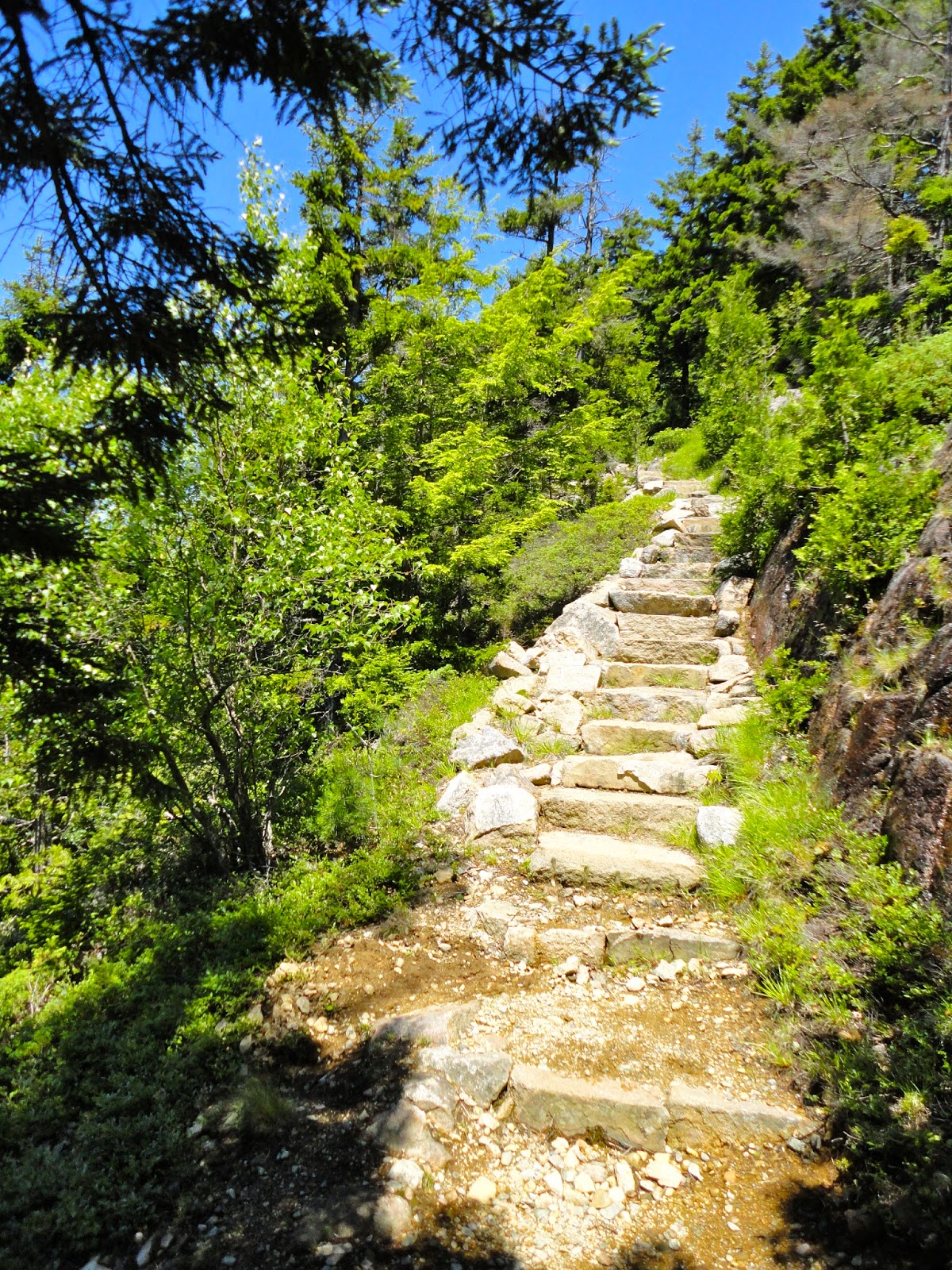
The last section of trail to the summit is a bit of a scrambling doozy! For me, that's when the fun starts, get those lungs burning. 


We took a quick snap at the summit and then decided to continue on along the trail to The Triad. This would be another peak with a not so great view, but awesome trail work! The Day Mountain Trail descends over 0.5 miles until it reaches more carriage roads. Directly across the bridge is the trailhead for The Triad Trail. The post said 0.3 miles to the summit... I don't think we were anticipating gaining as much elevation as we did. In 0.3 miles the elevation gain is around 500 feet. Yikes. 


Look at that scramble! 

We might have gotten slightly lost/off trail at one point. The blue blazes were scarce, quite hard to see, so be careful. Not to mention, there was a mound of leaves covering the trail. They can be slippery little buggers. 


Need a good workout? Run up and down this section a few times... you'll feel it. I think it was at this point I asked, "who's idea was this?" Oh, yeah. Mine. 


I think that is the largest cairn I have ever seen... Don't worry, there are five rocks forming the structure, the fifth one is hiding out in the back, we checked. 


We stopped at the summit for a quick breather before heading back down. I'm slightly regretting not putting sunscreen on today. 

Once we made it down the 0.3 miles back to the carriage roads, we decided to take a walk along the Day Mountain carriage road until we met back up with the Day Mountain Trail. This way, we didn't have to summit the peak again. We ended up walking for about a mile and half, but I'm not complaining. It was quite peaceful and beautiful. 


We had a few encounters with these guys! Boy, were they huge. The horses pull carriages up and around Day Mountain to the summit and back down. I can't imagine how they are feeling on a hot day like today! 

The carriage road eventually met up with the Day Mountain Trail, at its first crossing with the road. So, we didn't have too much trail to hike down to get back to the starting point. Luckily, the planks are part of this first section of trail, so you know I was pumped to tramp along those again. 


Friday, June 27, 2014

Beech Mountain; West Ridge and South Ridge

Hiking buddies: Alex and Pheebs
Weather: low 70s, sunny
Mountain: Beech (Acadia National Park)
Elevation: 839ft
Ascent: West Ridge and Beech Mountain Loop
Descent: South Ridge and Valley Trail
Miles of trail: 2.5
Total miles this year: 85.9

I love morning hikes. Nothing gets you more pumped and energized for the day than a nice hike on a sunny, summer morning. Of course, good company helps, too. 

I had mentioned in a previous blog entry on Beech Mountain that I had never hiked the South or West Ridge Trails before. You can read that entry by clicking here. I was encouraged by a friend of mine to give them a shot sometime. Well, that sometime was this morning! 

Phoebe can always tell when I'm getting ready to go out on a hike. It's quite hard to get out the door without her noticing and wanting to tag along. This time around, I just couldn't look into those sweet, puppy dog eyes and tell her "no." Therefore, she had to come. Alex didn't mind; they're new bffs. 

The West Ridge Trail heads straight up to the summit as it overlooks Long Pond. I'm sorry to say that I really don't remember too much about the trail- just that it was steep, I huffed and puffed, and the views overlooking the pond were breathtaking. Alex does a pretty good job distracting me. 


This trail is another fine example of the dedication it took from volunteers to build the trails in Acadia, and the dedication it continues to take to keep the trails well maintained. I can't even begin to fathom the man power, sweat and time that went into cutting, lugging and placing those stone steps. Kudos to all involved! 

We took a nice long break at the top. Pheebs was going nuts with all the hikers around today. Beech Mountain was a popular place to be. 


I love the fire tower on top of Beech. The observation deck offers a spectacular view of the surrounding area. 


It took a little convincing to get Phoebe to climb the metal stairs, but she did it! Although, she wasn't quite sure what to do while up there...

Don't jump!
All tuckered out...
We took a quick snapshot selfie before heading back down the tower, I suppose we had to let others enjoy the opportunity the fire tower provides.


I probably could have stayed at the summit all day long. The weather was gorgeous, sun was shining, people were coming and going. It was so peaceful sitting on top of the world. But, alas, I had to get on down the mountain to go to work. Whyyyyyyyy. 

Fancy cairn
We took the South Ridge Trail down the mountain. Now, this was a nice trail winding through the thick forest, full of open granite faces, stone steps, and (again) wonderful views of Long Pond. 


Fini. 

A beautiful start to my day, in so many ways.

"The Four Peaks"

Hiking buddy: Marina
Weather: high 60s, foggy
Mountains: Bald Peak, Parkman, Gilmore and Sargent (Acadia National Park)
Elevations: 974ft (Bald), 941ft (Parkman), 1,036ft (Gilmore), and 1,373ft (Sargent)
Ascents: Maple Spring, Bald Peak Trail, Parkman Mountain Trail, Grandgent Trail, Maple Spring Trail, Sargent South Ridge Trail
Descents: Bald Peak Trail, Parkman Mountain Trail, Gradgent Trail, Sargent South Ridge Trail, Hadlock Brook Trail, Maple Spring
Miles of trail: 5.4
Total miles this year: 83.4

Guess what? Marina is back from Indiaaaaa. Woot! Woot! And, randomly, the boss gave me a weekday off. That doesn't happen often... So, I ran with it. Or, shall we say, hike? Out of a forecast for the week full of sunshine and warmer temps, Wednesday was looking pretty grim in comparison; rain showers. 

Since Marina is only home for a couple weeks, I gave her the honor of picking the peak to hike. She suggested Sargent, so I suggested we do what I call "The Four Peaks". That would be Bald Peak, Parkman Mountain, Gilmore Mountain, and Sargent Mountain. Four peaks plopped in a little grouping on the way into Northeast Harbor. 

This can be a strenuous hike, but it is a must do in Acadia. 

We parked in the Norumbega Mountain pull-off, crossed the street, and started in on Maple Spring for about 0.2 miles. Just before the carriage road, there will be a trailhead on the left for the Bald Peak Trail. This trail follows a little stream before reaching another carriage trail. At this point, you're above tree line and can catch your first glimpse of the surrounding landscape and waters. 

Well, we couldn't really see through the fog!


There's a pond over there somewhere, I swear. 

Marina shared stories from her trip to India. Travel stories make excellent trail conversation. I love hearing about all of her adventures!

We finally made it to the summit of Bald Peak... I know there is a summit marker up there somewhere...


From here, it's only 0.3 miles to the next summit; Parkman Mountain. Piece of cake. The trail heads down a few hundred feet, quite abruptly, and then quickly gains elevation back to 941 feet. The fog was still rolling in. 


After the slight scramble of about 0.2 miles, you are at the Parkman summit. Again, not much of a view today...


Now, this is where the trail gets super fun... it's time to get back into the forest full of vibrant moss, fiddlehead ferns, wild flowers and spider webs!


From the summit of Parkman to the summit of Gilmore, the trail covers about half a mile. Another loss and gain of around 300 feet in elevation. Not too shabby! A quick snapshot at the summit of Gilmore, and then we continued on our way toward Sargent.


The fog just wasn't going anywhere. 

Here come the fiddlehead ferns!


The trail looks a liiiiittle wet, no? It was a very muddy adventure. Eventually, the trail comes to an end, and there are two options for getting to the summit of Sargent. The quickest, hardest option would be to take the Grandgent Trail. It's a bit of a lung buster. The second option takes a little bit longer, but is also easier; Maple Springs Trail. I had actually never taken the Maple Springs Trail up to the summit before, so we went with that route for this adventure. After all the rain we had had, the trail was certainly living up to its name...


Not too far up the trail we ran into this little guy...


We totally weren't sure if it was real or not. Seriously, I made Marina poke him with a stick! I mean, she did it gently and in the nicest way possible. Sure enough, this guy was alive and real. Onward...


Marina is terrified of ticks... Today's hike was full of narrow, bushy trails; not her favorite kind.


Which way to go? Ha...

Once we had reached the summit, the fog had decided to roll on out and the sky opened up to a beautiful sunshiny day!


To head down back to the car, we took the South Ridge Trail down to the Hadlock Brook Trail, back to Maple Spring and to the main road. Phew! 


Hiking down the South Ridge, you can see the summit of Cedar Swamp in the near distance. I don't think I had ever noticed that peak before. Although, I didn't know Cedar Swamp existed until last year! Whoops. Apparently there is an old plane wreck somewhere over there. Must bushwhack and see!

Snapshots from the Hadlock Brook Trail...


The trail crosses the stream numerous times, which after all the rain was gushing water and roaring up a storm. Thankfully, neither Marina or I fell in. The stream eventually leads to a stunning waterfall with a carriage road bridge just beyond, conveniently called "Waterfall Bridge." 


Standing on Waterfall Bridge
A little under a mile left to go at this point, and you're back to the parking area. What a beautiful day it was to be out in the woods. Heavy rainfall always adds a nice touch to the soundtrack of nature on a hike like this one. I love hearing the rushing water.