Saturday, April 12, 2014

Beehive and Champlain; South Ridge

Hiking buddy: Ian
Weather: 60, sunny!
Mountains: Beehive and Champlain (Acadia National Park)
Elevation: 520ft (Beehive) and 1,058ft (Champlain)
Ascent: The Beehive Trail, South Ridge Trail of Champlain
Descent: North Ridge Trail, Orange & Black Path, and the Park Loop Rd.
Miles of trail: 4.8
Total miles this year: 27.9

After a long evening and day of strategic planning, aka; sitting for hours on end,  I was ready for a nice, looooong hike. Probably should have shared that information with my hiking buddy, but I had a feeling he wouldn't want to go if he knew it was going to be a long one. And, I really wanted the company.

We couldn't have asked for a more perfect day for a long leisurely hike. The air was warm, the breeze was warm, the sun was shining. A beautiful spring day!

I wanted a challenge; something fun, interesting, and exerting of strength. The answer was very easy; Beehive! It is, after all, Acadia's very own jungle-gym. But, Beehive just wasn't going to be enough for me, I wanted more trail under my feet. Gorham would have been a nice addition, but not quite long enough. Champlain was the only logical answer. Luckily, I didn't have to twist Ian's arm too hard. Off we went!

I'll spare you the details of both peaks, since I have already described the trails in previous blogs, but I will share pictures with you from today's hike.

First off:

For my original post on Beehive, click here

For Champlain, click here.

The only change to the Champlain hike, is that we took the Orange & Black Path down to the Park Loop Rd. This trail branches off the North Ridge, and brought us closer to our end point than if we had continued down with the North Ridge. The Orange & Black Path winds along the east side of the mountain, eventually splitting into two options; one path meets up with the Precipice Trail, the other continues on down to the Park Loop Rd.

Pictures from today... enjoy!

The *classic* Sand Beach shot from Beehive


Weird lighting, but interesting perspective! Beehive


Champlain summit


Good company, sun shining on my face, a beautiful creation all around to explore. A wonderful day!

That's all, folks.

Sunday, April 6, 2014

Penobscot; Penobscot Mountain Trail

Hiking buddy: Becca
Weather: 48, not a cloud in the sky!
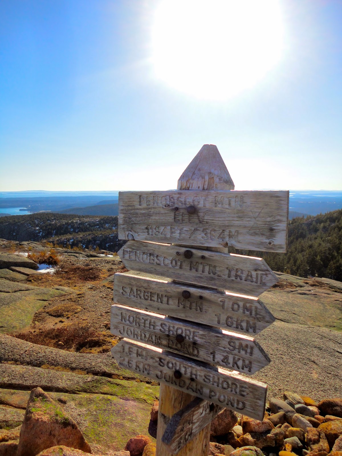
Mountain: Penobscot (Acadia National Park)
Elevation: 1,194 ft
Ascent: Spring Trail and Penobscot Mountain Trail
Descent: Penobscot Mountain Trail and Spring Trail
Miles of trail: 3.0
Total miles this year: 23.1

Oh, boy... what an adventure today! 

Being cooped up inside for the better part of the afternoon (annual meeting...) while the sun taunted me from the window was NOT enjoyable. My toes were dancing under the table, antsy to get out on the trails. 

My goal for the day: conquer Penobscot. If I had truly had my way, we would have hiked the Jordan Cliffs. However, it was the wiser choice to stick with the Penobscot Mountain Trail. Considering the amount of snow and ice we encountered on that trail... I'm not so sure I want to find out what condition the Jordan Cliffs is in right now. We'll save that for another day.

Start of the Spring Trail
Jordan Stream
The crampons came out immediately, the path down to the carriage road and the start of the trail was covered in ice. I noticed a nice fresh set of tracks in the patches of snow, THANK YOU, whoever you are; you helped us determine the depth of the drifts and the safest route across. Bless you. Boy, was that stream ROARing today! Don't fall in.

We experienced it all...

Snow...
Ice...
Snow covered ice!
And we had yet to reach the official start of the Penobscot Mountain Trail, folks! We knew right away we were in for a challenge. We still had to finish the Spring Trail... it wasn't very... spring-like.

A brief description of the Spring Trail: from steep, twisting steps to tight squeezes between and around large boulders, there is never a dull moment. Wooden bridges and railings, with a few iron rungs, help you along the way. In just under a half mile, the elevation gain is around 650ft!


I know the rangers like to kindly remind us to not stray from the trails; leave no trace! However, if you turned around the corner and came face to face with this:

... you would venture off the trail, too! I made it up to the tree on the right and bailed. I hugged that strong, beautiful tree and veered off onto a ledge to the right. Good decision! Becca and I found another way to the top of this section. Just a little rock climbing involved. No big deal.


The woodpeckers have already been at work! This little guy has some more whittling to do. I've seen much better carvings.

Penobscot Mountain Trail branches off the Spring Trail, just below the treeline. The trail ascends the south ridge of the mountain. A mile long of trail above the treeline with panoramic views of Jordan Pond, Pemetic Mountain, the coast and outer islands, more mountains... so beautiful. We followed the cairns along the exposed granite as the trail twisted its way to the summit, taking in the view each step of the way. Although, Becca was doing her best to wait until the summit to take her full look around; that is so hard to do! 


I always turn around to sneak a peak! This photo was taken looking down the south ridge, Bracy Cove and Seal Cove in the distance. Look at that cloudless sky! 


Yes, there was still snow in patches along the exposed face. Becca didn't hear my warning about the depth of the snow in this spot. She was a little surprised by how far her foot sunk in! Whoops.

I've enjoyed hiking with Becca... she has never done any of these trails and peaks before. She's just on the island for the semester. I'm trying to get her to experience as much of Acadia as she can before she heads back out west. It was funny listening to her commentary today along the ridge. It's very hard to determine where the summit is; you reach the top of one section and glimpse an even taller section up ahead, repeat. Many times! Becca enjoyed every moment.


With nearly a complete 360 degree view, why would you not want to hike this mountain?

The wind was picking up, the sun was going down, we snapped a few fun shots and then began our descent back along the south ridge.

Becca


I knew the hike down would be a little tricky, once we got back below the treeline and the snow and ice came into play again. Surprisingly, we made it down rather quickly. With a few detours, a little tree branch gripping, and some cautious crab-walking and butt sliding, we made it safely down the mountain!


Becca and I both felt rather proud of our accomplishment for the day. Once safely back to the car, I had dreams of a hot shower, warm scrambled eggs for dinner, and a mug of hot cocoa. Perfect.


Friday, April 4, 2014

Beech Mountain

Hiking buddy: Ian
Weather: low 40s, sunny, close to sundown
Mountain: Beech Mountain (Acadia National Park)
Elevation: 839 ft
Ascent: Beech Mountain Loop (0.7miles)
Descent: Beech Mountain Loop (0.4miles)
Miles of trail: 1.1
Total miles this year: 20.1

Sometimes... it's hard having to sit at my bench at work, looking out the window that is staring me back in the face; showing me what I'm missing in the outside world. Around four in the afternoon the sun hits low enough for its rays to shine directly in, causing me to squint and look like a fool. But, do I close the blinds? Heck no. The warmth feels good. It's a reminder that I need to get out and enjoy the remaining hours of daylight after work.

Today was one of those days. I couldn't wait to go on an adventure; I dragged my friend, Ian, along for the ride. Or, shall we say, hike. I gave him the option: Beehive or Beech? We decided on Beech Mountain. 

Now, there are a few ways to go about hiking Beech Mountain. The actual base of the mountain is by the ends of Long Pond and Echo Lake. There is the Beech Cliff trail which begins by Echo Lake; it's a ladder trail, very fun, slightly difficult, and usually closed for Peregrine Falcon nesting. Then there are the West Ridge and South Ridge trails, they start by Long Pond; which I have never done. Note to self: hike those trails! 

Or, you can drive to another trailhead that starts around 300 feet of elevation. There's a nice little loop that will take you the last 500+ feet to the summit of Beech Mountain; where the famous old fire tower still stands tall. Considering the state our trails are in this time of year... still covered in ice and snow, I felt it was best to stick with the simple Beech Mountain Loop. 

It didn't cross my mind that the park gate would be closed, or, in fact, that there would even be a park gate to begin with... we had to jump over the gate and walk up to the trailhead. I wasn't entirely sure what condition the trails would be in, naturally. It has been much warmer this week, I was assuming the snow would have melted away. I think the snow covered road was a good hint that that would not be the case.

In the parking lot area you will find three trailheads... The Beech Mountain Loop starts in the front right corner. The trail very quickly splits in two; you can take the steep trail (0.4miles) or take the more round-about route (0.7miles). Preferably, I enjoy taking the steepest route up. The other trail takes you along the ridge overlooking Long Pond and Mansell Mountain. A wonderful sight to hike towards! However, with the ice and snow cover, we took the safer route. Around the mountain we went! 


Luckily, I was able to slap the crampons on my hiking boots and walk with slight ease. Poor Ian, I didn't warn him beforehand. He's a champ. 

What I enjoy about this trail: it's nice and easy to start, a little stroll through the woods. Then, it breaks out into the open with a wonderful view of Long Pond and Mansell Mountain. The time was after six and the sun was getting quite low. Too early for sunset, but still beautiful.


Around the corner... and there's more snow!


With a slight scramble for the last tenth of a mile, you are quickly rewarded with a glorious view!


And, of course... the fire tower:


How else do you think you can get a shot like the one above? You have to climb the stairs of the fire tower and look out over the railing. The last time I was up there; it was a Fall painting. Today, you can see the hope of spring and warmer weather to come... I hope very soon!

Ian and I are quite similar... we both enjoy making a complete loop. Down the steeper trail we went... I think that's where the adventure really settled in. Someone before us had done some slipping... and butt sliding! Genius. Thank you trees and little branches for allowing me to latch on, and thank you Ian for your patience.

This afternoon, adventure was tugging at my sleeve. I'm glad I decided to answer its call. I'm still gaining my hiking legs back, winter can really kick a girl out of shape.